
Lions that have collars that transmit their position by text message, and a map is automatically created? Sweet.
The original article mentions the text messaging but the collar manufacturer's website shows a bunch of different methods of communication: UHF/VHF radios or the ARGOS, GLOBALSTAR, and IRIDIUM satellite networks. And not only is GPS data sent but also data from other sensors: accelerometer, mortality, hibernation, virtual fence, proximity, and temperature.
Like I said, sweet.
Showing posts with label maps. Show all posts
Showing posts with label maps. Show all posts
Sunday, December 11, 2011
Monday, September 13, 2010
Make Money!
Playing Poker! Like my previous post these locations were also from the latest issue of ESPN the magazine. I was actually surprised that so many places were in LA. The only time I was in the Hollywood Park Casino it was surreal - especially when you're used to stumbling through a Vegas casino at 4 in the morning. Also, Berlin played a concert that night which was the strangest concert I've ever been through (note to self: don't wait to hear Take My Breath Away for any length of time no matter your love of Top Gun). And I've never been at a 'real' card table so there's that. Also, these places have nothing on the Cayucos Tavern (complete with MySpace page!). Liquor in front, poker in the rear. Heyo!
View Top 10 Places in the Country to Make Money Playing Poker in a larger map
View Top 10 Places in the Country to Make Money Playing Poker in a larger map
Friday, September 10, 2010
This is not what we do on Baseball Trip
I realize this is a bit out of character for this blog (misogyny anyone?) but after getting the September 20th issue of ESPN the magazine (The List Issue) and reading Bill Simmons' tweet about Edge James' favorite strip clubs, I had to make a map. (And no, I haven't forgiven James for 1998). Get Bill's first book: Now I Can Die in Peace , or his second: The Book of Basketball
 .
.
View Edge James' favorite Clubs in a larger map
View Edge James' favorite Clubs in a larger map
Wednesday, July 28, 2010
Oh give me a home....
Every time I either drive or fly in and out of Los Angeles I think about moving. I grew up in a small town and being surrounded by so many people and so much stuff can be kind of clausterphobic. Plus it's hard to imagine having a family here. And houses cost a LOT of money. So I was interested when Barry Ritholtz (an investment professional cum financial blogger) commented on a site at Forbes about where Americans are moving (using IRS data).

(Look, people move to LA from the east coast and then from LA to the South and the west coast).
This tool would be a great compliment to Richard Florida's "Who's Your City" website (and book too, although I haven't read it). Choosing where to live is a multi-dimensional problem that is hard to contemplate. These sites are a great start.
Somewhat randomly the Wikipedia entry on Who's Your City says that my boy Tim Harford has been critical of the book. This couldn't be verified because Wikipedia's source was an article in Canadian Geographer (which I don't have access to) and the only mention I could find was Tim referencing Florida's work.
Tuesday, July 6, 2010
Book Report: The Girl Who Played with Fire
The Girl Who Played With Fire, book two of Stieg Larsson's Millenium Trilogy. I finished this book on a bus/train ride from San Luis Obispo to Union Station (Amtrak!). Then I took the FlyAway Shuttle from Union Station to LAX. Fun!
View Bus/Train Fun! in a larger map
View Bus/Train Fun! in a larger map
Sunday, December 27, 2009
The Great Long Beach Taco Off Part 2 (2009)
Last year around holiday time I went with some fam (mom, sis, aunt, uncle, cousins, their kids) to the Aquarium of The Pacific in Long Beach. Before we went I had the BRILLIANT idea of having a taco off. Cousin Dave, from Ohio, loves him some Mexican food, especially tacos. So we went to King Taco and Tacos Don Chente in the LBC. It was awesome. His kids liked it, we LOVED it, and we all proceeded to have a wonderful day watching fish (and stuff).
For those interested in how the gringos differentiated: KT had better Asada (which was especially a hit with my little cousin), but we (I) liked Chente's Pastor and salsa bar. Also Chente had a little nicer decor and was less crowded (good for our group) plus we had REALLY REALLY COLD beers (mom's fave). KT is much more of a landmark so I'm suggesting we go there again. But we might to go El Gallo Giro and I'm really going to push for El Taco Loco No 3. More to follow.
And, of course, the obligatory map:
View The Great Long Beach Taco off Part 2 (2009) in a larger map
Oh, and don't think I haven't started thinking about next year: Taqueria La Mexicana and Hole Mole are both on 4th Street - maybe I can get someone interested?
Wednesday, December 9, 2009
Maps Show Data Good
As you may or may not know, I think maps area perhaps the great information communication medium the world has ever seen. Not that I'm given to hyperbole or anything. From Matthew Yglesias comes this series of color coded maps that explains on a state-by-state basis how different age groups and income levels feel about the public option in the current raging health care debate. (Quick aside - a public option is a good thing but I won't write anything more because I don't want to have to tag this post as a rant).


Tuesday, December 8, 2009
What I Did On My Summer Vacation
As the year comes to an end I've been taking inventory of the old blog and noticed that during the Summer my posting fell from my typical inconsistency of ~1 every 7-10 days to 1 in July and none in August. Well it turns out that I was taking 2 classes (1 each at UCLA and USC) and working and not posting. The USC class was my last class in the GIST Certificate program (I'm certified!). A week in Catalina that include lots of hiking, playing with GPS units, and a night snorkel (yeah, it was a-freaking-mazing). The UCLA class was equally awesome - Geography of Los Angeles. We explored a ton of themes and did a bunch of field trips (a trip to the LA River led by nature writer Jenny Price, Westwood walkabout including this apartment building designed by Lautner, and taking a Metro bus up and down Sunset Blvd.).
My partner and I did a final project on the LA River. We had to create a tour, make a google map (below), and then do a short presentation in the Pecha Kucha style (Wikipedia). Pecha Kucha limits your presentation to 20 slides and 20 seconds for each slide. So you have to choose images with maximum impact, choose your words carefully, and practice. It's great, I wish that my work presentations had similar constraints.
View LA River Map in a larger map
Monday, December 7, 2009
US Interstate System as London Tube Map
Awhile back Matthew Yglesias linked to this picture (from the Good Blog) of the US Interstate system made to look like the London Tube map (Wikipedia).

For those who have never been to London, go. I was only there for a bit but had a great time. Getting around on the Tube is intuitive, in no small part because of the ground breaking Tube map. Additionally you can sit back and see all sorts of slices of life because EVERYONE takes it. Whatever ethnicity or occupation that can be imagined will be on the Tube. Including jet lagged pasty American tourists.

For those who have never been to London, go. I was only there for a bit but had a great time. Getting around on the Tube is intuitive, in no small part because of the ground breaking Tube map. Additionally you can sit back and see all sorts of slices of life because EVERYONE takes it. Whatever ethnicity or occupation that can be imagined will be on the Tube. Including jet lagged pasty American tourists.
Wednesday, October 21, 2009
LA Delis
An Email I sent to my friends today (slightly edited for the internets). Yes I know it's International Day of the Nacho. Also, I looked to see if www.idon.com was taken. It is. By some guy promoting an album called Sexy Robotica. Yum.
Alas I only mapped one Hat and one Brent's location:
View LA Delis in a larger map
I was reading the LA Times today and ran across this story.
Which got me thirsty for some pastrami. Which got me to thinking about club sandwich and the fact that it's been awhile. So I was just curious if anyone felt like doing a club sandwich outing this weekend or next? It doesn't necessarily have to be at any of the places listed in the article. But here they are:
Nate 'n Al in Beverly Hills
Factor's in Pico-Robertson
Junior's in West L.A.
Greenblatt's on the Sunset Strip
Art's in Studio City
Canter's in the Fairfax district
The various Hat locations
Langer's near MacArthur Park
Brent's in Northridge and Westlake Village
I've never been to Nate 'n Al, Factor's, Greenblatt's, or Art's. But I love everyplace and would be down to go anywhere. Except Jerry's. That place sucks.
Alas I only mapped one Hat and one Brent's location:
View LA Delis in a larger map
Thursday, September 24, 2009
McDonald's Map!
Via Felix Salmon comes this sweet picture by Stephen Von Worley that presents a visualization of McDonald's restaurant concentrations in the US. Crazy!
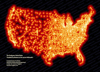
So South Dakota, you are the winner! (that doesn't explain how you are still the 16th fattest state)
Even more intriguing about Worley's site was his link to Strange Maps. Whoa. Let me say again: WHOA.

So South Dakota, you are the winner! (that doesn't explain how you are still the 16th fattest state)
Even more intriguing about Worley's site was his link to Strange Maps. Whoa. Let me say again: WHOA.
Wednesday, September 16, 2009
25 Delectable Dining Deals
Two months off? No problem! Evidently the Best Summer Ever includes little to no blogging. Never fear because the LA Times just published a list of 25 Delectable Dining Deals. Includes personal favorite Golden State Cafe!
Map included!
View LA Times 25 delectable dining deals in a larger map
Unfortunately the map contains no placemarks for pork shoulder.
Map included!
View LA Times 25 delectable dining deals in a larger map
Unfortunately the map contains no placemarks for pork shoulder.
Friday, July 10, 2009
Who wants to buy a house?
View Untitled in a larger map
From the good people at Curbed comes an article about the last four luxury apartment towers to be built in Los Angeles (well, until residential real estate goes through its current bust and comes back to an inevitable boom).
Anybody have a few extra (million) dollars lying around?
Thursday, June 25, 2009
Maybe You Should Move to El Paso

My sister, bless her little heart, knows that I really like maps. Especially Google Maps. So when she sent me a link today about an interesting Google Map mashup I was understandably excited. The link she sent, from a company named PSFK who's about section says this:
PSFK is a trends and innovation company that publishes a daily news site, provides trends research and innovation consultancy and hosts idea-generating events. We aim to inspire our readers, our clients and our guests to make things better - whether that’s better marketing, better lives or a better world.
This mission statement nonsense aside, what I thought was interesting was that PSFK titled the page "Google Map: When Will Recession End Locally?" The reason I find this interesting is that when you look at the map on it's original site from the Sacramento Bee, it's not really about when the recession will end per se, rather it is a visual representation of when a certain organization (IHS Global Insight, a "leading economic forecaster") thinks that different areas will return to pre-recession employment levels. Whew.

All this got me thinking about how different people have different ways of measuring what exactly constitutes a recession (or a depression for that matter), how to determine when a recession starts or ends, and how exactly does it affect day to day lives of people. I think we can all agree that employment is a part but is it the only part? I would say no. Then again, I'm 100% unqualified to make any kind of economic arguments. For a good place to read about the economy and finance I would definitely point you to the blog Calculated Risk. They even have a recent post detailing which states are currently in a recession. The answer? Basically everywhere except North Dakota. Maybe we should all move to Fargo instead of El Paso? I doubt we should move to Youngstown, OH or Elkhart, IN though.
Friday, June 12, 2009
NYC Metro Cuff

From Tiffany Burnett (ht notcot), a New York City Metro Map wrist cuff. Map Jewelry! Somewhat cooler than my London Tube T-shirt that my sister wouldn't let me wear until we left London.
Wednesday, May 27, 2009
Baseball Trip 2009
Hey kids it's been awhile since my last post. I finished a GIS class and worked on a pretty cool Google Map project (which is not quite ready for prime-time but I hope to get version 0.1 up running at some point in the next couple months). I also went on a 5-stadium, 1300 mile baseball roadtrip through America's Rust Belt and Ontario. Good times!
View Baseball Trip 2009 in a larger map
View Baseball Trip 2009 in a larger map
Thursday, April 23, 2009
ComputerLove - Google Maps Typography
Fortunately for me my sister is awesome. Not only is she a talented artist (one of the websites that she designed the artwork for was recently highlighted in the Huffington Post), but she also finds time in her busy day to forward me cool links like this collection of photographs gleaned from Google Maps.
The prior link is a collection of pictures were found on Google Maps that resemble the letters A-Z. Some are man made, some natural. Pretty cool.
The prior link is a collection of pictures were found on Google Maps that resemble the letters A-Z. Some are man made, some natural. Pretty cool.
Thursday, April 16, 2009
Lat Long Answers!
Evidently I dominated Google's latest Where In The World Is... contest, although I should have paid more attention to the other Google LatLong blog posts because if I had spent more time reading about the Great Lakes in the post about the United States' Third Coast I would have found the answer to the bonus question. Oh well, next time Google, next time.
Monday, April 13, 2009
Best Beer Bars in LA
View Toddmartens's List of Best Beer Bars in a larger map
I was perusing the LA Times today and a nice little list caught my eye. Seems like Todd Martens, a staff member, compiled a list of 24 beer bars in the greater LA area. I've been to more than a few of these places, and some have multiple locations (Yardhouse, Father's office, etc.). Missing from the list and deserving mention, although not quite technically a bar, is The Golden State Cafe. They have a GREAT beer selection and food (and even better owners!).
Martens also has a list of LA's best microbreweries but it seems just a tad incomplete (no mention of Manhattan Beach Brewing Company or no shout-out to the no-longer-a-brewery-but-still-has-giant-vats-in-the-bar Westwood Brewco?). Although to Golden State's credit they do carry Craftsman beer on tap.
Google LatLong: Where in the world is ...
The Google LatLong blog sometimes has fun little exercises for finding interesting places in the world. In the latest version of Google LatLong: Where in the world is ... I think I was able to come up with the first ten but not the bonus question.
In order:
1) Los Angeles
2) Las Vegas
3) San Francisco (Coit Tower)
4) San Sebastian
5) Pittsburgh
6) Ottowa
7) Helsinki
8) Auckland
9) Cincinnati
10) Girona (Near barcelona)
Anybody have any idea on number 11?
In order:
1) Los Angeles
2) Las Vegas
3) San Francisco (Coit Tower)
4) San Sebastian
5) Pittsburgh
6) Ottowa
7) Helsinki
8) Auckland
9) Cincinnati
10) Girona (Near barcelona)
Anybody have any idea on number 11?
Subscribe to:
Posts (Atom)
